Language selection

Weather shortcuts

Gulf - Port au Port

Forecast

Marine Forecast

Issued 10:00 AM NDT 08 May 2026

Today Tonight and Saturday.

Wind light becoming north 10 to 15 knots this afternoon then becoming southwest 10 to 15 near noon Saturday.

Showers ending Saturday morning.

Waves

Issued 06:00 AM NDT 08 May 2026
Today Tonight and Saturday. Seas 1 to 2 metres subsiding to 1 or less this morning.

Extended Forecast

Issued 03:00 AM NDT 08 May 2026
Sunday Wind southeast 15 to 20 knots increasing to south 25 to 35 in the afternoon.
Monday Wind south 25 to 35 knots.
Tuesday Wind variable 15 to 20 knots.

Ice Forecast

Issued 10:00 AM EDT 8 May 2026 Today Tonight and Saturday Bergy water. Consolidated rotten first-year ice along parts of the Quebec coast. 

[ Canadian Ice Service ]

Stay connected

ATOM

Weather Conditions

Skip Image

Zoom-in to make a selection

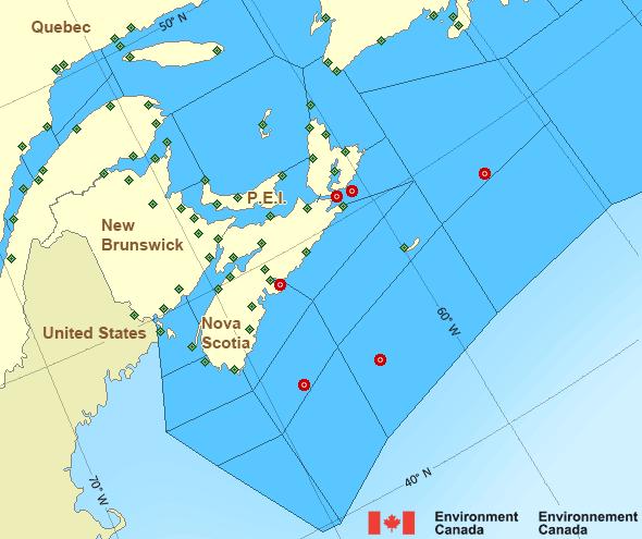
Map of Atlantic - Maritimes marine weather areas East Scotia Slope - 44137 Cap-Chat Burgeo Île Bicquette New Carlisle Îles de la Madeleine Airport Port Menier Summerside North Cape Pointe-au-Père Mont-Joli Airport La Pocatière Wreckhouse Banquereau - 44139 Port aux Basques Sagona Island Gaspé Airport LaHave Bank - 44150 Halifax Harbour - 44258 St. Lawrence Stephenville Airport Western Head Winterland Branch Hill Île aux Perroquets Beaver Island Baccaro Point St. Stephen Pointe-des-Monts Saint John Airport Sept-Îles Airport Point Lepreau Greater Moncton Roméo LeBlanc Int'l Airport Longue-Pointe-de-Mingan Miscou Island Île Rouge Kouchibouguac Pointe-Noire Kouchibouguac Havre-Saint-Pierre Airport Grand Manan Fundy Park (Alma) Miramichi Charlo West Chedabucto Bay – 44489 Bathurst Airport Baie-Comeau Airport Bas Caraquet East Chedabucto Bay – 44488 Nappan AAFC East Point Charlottetown Airport Yarmouth Airport Cap-d'Espoir Tracadie J.A. Douglas McCurdy Sydney Airport Shearwater Airport St.Paul Island Sable Island Parrsboro North Mountain Rivière-la-Madeleine McNabs Island Lunenburg Kentville AAFC Ingonish Beach Hart Island CFB Greenwood Grand Étang Eskasoni (First Nations) Debert Caribou Point Brier Island
Legend:
buoy Buoy
land station Land Station
Ice Conditions

Ice Forecasts

Issued 10:00 AM EDT 8 May 2026 Today Tonight and Saturday

Ice Edge

Ice edge estimated from Quebec near 5006N 6642W to 5001N 6603W to
4956N 5959W to 5102N 5743W to Newfoundland near 5047N 5708W. Sea ice
north of the ice edge.

Ice Coverage

Bergy water. Consolidated rotten first-year ice along parts of the
Quebec coast.


Iceberg Bulletin

Issued 3:04 PM EDT 7 May 2026

Iceberg Limit

Iceberg limit at 0000 UTC 8 May estimated from Newfoundland near
4655N 5545W to 4130N 5050W to 4220N 4635W to 4730N 4310W to 5310N
4705W to 5900N 5500W to 6000N 5300W to 5645N 4700W then eastward.

Iceberg Count

No confirmed icebergs except less than 10 icebergs northeast of the
western iceberg limit.
Warnings

No watches or warnings in effect.

Synopsis

Technical Marine Synopsis

Issued 10:00 AM NDT 8 May 2026 Today Tonight and Saturday At 10:00 a.m. NDT today trough located over Banquereau.
By 3:00 a.m. NDT Saturday trough located on a line north-south
over eastern Newfoundland.

At 3:00 a.m. NDT Saturday approaching ridge located on a line
north-south over the Maritimes.

Marine Weather Statement

Issued 9:59 AM NDT 8 May 2026 A trough of low pressure over Banquereau will move to lie over the
Northeast Coast of Newfoundland tonight. Strong to gale force
southerlies to southeasterlies ahead of the trough will shift to
strong west to northwesterlies as it passes.

Marine interests are advised that gale warnings are in effect for
Belle Isle Bank, Funk Island Bank, and Northern Grand Banks.

Atlantic - Maritimes Area

Another Region

Features

Colour-coded weather alerts

Learn more about weather alerting in Canada

Date modified: