Language selection

Weather shortcuts

North Labrador Coast

Forecast

Marine Forecast

Issued 04:00 PM NDT 18 May 2026

Tonight and Tuesday.

Gale warning in effect.

Wind west 25 knots except northwest 35 over northern sections Tuesday morning and afternoon. Wind diminishing to west 15 to 20 Tuesday evening.

Showers or flurries becoming flurries this evening. Visibility 1 mile or less in precipitation.

Waves

Issued 06:00 AM NDT 18 May 2026
Today Tonight and Tuesday. Mainly ice covered.

Extended Forecast

Issued 04:00 PM NDT 18 May 2026
Wednesday Wind west 15 to 20 knots diminishing to variable 10 to 15 in the afternoon.
Thursday Wind north 25 knots.
Friday Wind north 25 knots.

Ice Forecast

Issued 10:00 AM EDT 18 May 2026 Today Tonight and Tuesday 6 tenths first-year ice including a trace of old ice. Consolidated first-year ice along parts of the coast. 

[ Canadian Ice Service ]

Stay connected

ATOM

Weather Conditions

Skip Image

Zoom-in to make a selection

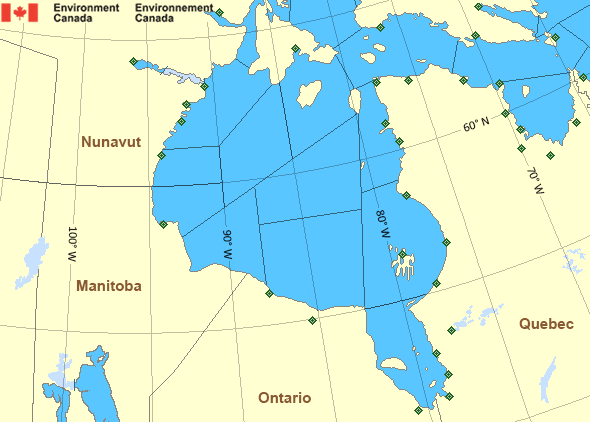
Map of Hudson - Hudson Bay marine weather areas Fort Severn Airport Churchill Airport Peawanuck Airport Moosonee Airport Coral Harbour Airport Salluit Airport Kuujjuarapik Airport Puvirnituq Airport Umiujaq Airport Aupaluk Airport Kangiqsujuaq Airport Kangirsuk Airport Kangiqsualujjuaq Airport Kuujjuaq Airport Quaqtaq Airport Baker Lake Airport Tasiujaq Airport Cape Kakkiviak Kimmirut Airport Wager Bay Iqaluit Airport Kinngait (Cape Dorset Airport) Whale Cove Airport Sanikiluaq Airport Rankin Inlet Airport Inukjuak Airport Arviat Airport Akulivik Airport Chesterfield Inlet Airport Wemindji Airport Waskaganish Airport La Grande Rivière Airport Eastmain Airport Ivujivik Airport
Legend:
buoy Buoy
land station Land Station
Ice Conditions

Ice Forecasts

Issued 10:00 AM EDT 18 May 2026 Today Tonight and Tuesday

Ice Edge

First ice edge estimated from Labrador near 5151N 5606W to
Newfoundland near 5138N 5554W. Sea ice northeast of the ice edge.

Second ice edge estimated from Newfoundland near 5135N 5525W to
5200N 5510W to 5400N 5515W to 6200N 5940W then northeastward. Sea
ice west of the ice edge.

Ice Coverage

6 tenths first-year ice including a trace of old ice. Consolidated
first-year ice along parts of the coast.


Iceberg Bulletin

Issued 2:30 PM EDT 18 May 2026

Iceberg Limit

Iceberg limit at 0000 UTC 19 May estimated from Newfoundland near
4700N 5520W to 4325N 5015W to 4320N 4615W to 4845N 4335W to 5310N
4635W to 5550N 5010W to 5900N 5500W to 5955N 5310W to 5840N 4800W
then northeastward.

Iceberg Count

Unknown number of icebergs.
Warnings

Warnings (In effect)

Gale warning in effect

North Labrador Coast

Issued 4:00 PM NDT 18 May 2026

'Gale' force winds of 34 to 47 knots are occurring or expected to occur in this marine area. Watch for updated statements. Please refer to the latest marine forecasts for further details and continue to monitor the situation through Canadian Coast Guard radio or Weatheradio stations.

Synopsis

Technical Marine Synopsis

Issued 4:00 PM NDT 18 May 2026 Tonight and Tuesday At 4:00 p.m. NDT today trough located on a line northwest-southeast
over Labrador Sea.
By 4:00 p.m. NDT Tuesday low 995 mb located over the Northwest
Labrador Sea.

Marine Weather Statement

Issued 3:57 PM NDT 18 May 2026 A trough of low pressure over the Labrador Sea will intensify to form
a low in the Northwest Labrador Sea early Tuesday morning. Strong to
gale force west to northwesterlies are expected south of the low.

Marine interests are advised that a gale warning is in effect for
North Labrador Coast.

Hudson - Hudson Bay Area

Another Region

Features

Colour-coded weather alerts

Learn more about weather alerting in Canada

Date modified: