Language selection

Weather shortcuts

West Coast Vancouver Island South

Forecast

Marine Forecast

Issued 04:00 AM PST 06 November 2024

Today Tonight and Thursday.

Gale warning in effect.

Wind southeast 15 to 25 knots except southeast 25 to 35 northwest of Estevan Point today tonight and Thursday.

Periods of rain. Visibility 1 mile or less in rain.

Waves

Issued 04:00 AM PST 06 November 2024
Today Tonight and Thursday. Seas 1 to 2 metres building to 2 to 3 this afternoon except 3 to 4 northwest of Estevan Point overnight and Thursday.

Extended Forecast

Issued 04:00 AM PST 06 November 2024
Friday Wind southeast 15 to 25 knots diminishing to variable 10 to 15 in the afternoon.
Saturday Wind northwest 15 to 25 knots.
Sunday Wind southeast 30 to 40 knots.

Stay connected

ATOM

Weather Conditions

Skip Image

Zoom-in to make a selection

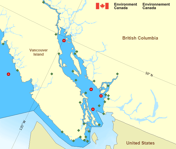
Map of Pacific - Georgia Basin marine weather areas Sentry Shoal - 46131 Halibut Bank - 46146 La Perouse Bank - 46206 Georgia Strait - 46303 English Bay – 46304 Discovery Island Esquimalt Harbour Kelp Reefs Malahat Race Rocks Lightstation Saturna Island Sheringham Point University of Victoria Victoria Gonzales Victoria Int'l Airport Ballenas Islands Campbell River Airport Comox Airport Entrance Island Fanny Island Nanaimo Airport Sisters Islets Estevan Point Port Alberni Tofino Airport Grief Point Howe Sound - Pam Rocks Powell River Airport Sechelt Squamish Airport Point Atkinson Sand Heads Lightstation Tsawwassen Ferry Terminal Vancouver Int'l Airport Vancouver Harbour West Vancouver
Legend:
buoy Buoy
land station Land Station
Ice Conditions

There is no ice forecast issued for this area.

Warnings

Warnings (In effect)

Gale warning in effect

West Coast Vancouver Island South

Issued 04:00 AM PST 06 November 2024

'Gale' force winds of 34 to 47 knots are occurring or expected to occur in this marine area. Watch for updated statements. Please refer to the latest marine forecasts for further details and continue to monitor the situation through Canadian Coast Guard radio or Weatheradio stations.

Synopsis

Technical Marine Synopsis

Issued 4:00 AM PST 6 November 2024 Today Tonight and Thursday At 4:00 a.m. PST today frontal system located on a line
northwest-southeast over western Bowie.
By 4:00 p.m. PST today weakening frontal system located on a line
northeast-southwest over Sandspit.

At 4:00 p.m. PST today frontal system located off Explorer.
By 10:30 a.m. PST Thursday weakening frontal system located from
the Central Coast to Cape Scott then to Explorer.

At 4:00 a.m. PST Thursday trough located off Bowie.
By 4:00 p.m. PST Thursday weakening trough located on a line
northwest-southeast over Cape St. James.

Marine Weather Statement

Issued 3:31 AM PST 6 November 2024 A frontal system over Bowie will weaken over Haida Gwaii this
afternoon. Ahead of the front, southerly gales over the offshore
waters will spread to west coast Haida Gwaii early this morning and
then shift to moderate to strong northerly in its wake. Southerly
gales will gradually ease today over northern coastal waters but
continue through tonight and Thursday over central coastal waters.

Another frontal system will track across the offshore waters tonight
and onto the North Coast Thursday morning. Ahead of the front,
southerly gales will re-develop over the offshore waters tonight and
then spread to west coast Haida Gwaii and northern coastal waters
overnight.

An approaching trough of low pressure will track across Haida Gwaii
midday Thursday and onto the North Coast in the afternoon. Ahead of
the trough, strong to gale force southerlies will continue over Bowie
and most northern waters Thursday before gradually easing in the
afternoon.

Pacific - Georgia Basin Area

Another Region

Features

WeatherCAN

Download and use the WeatherCAN app on your mobile device

Date modified: